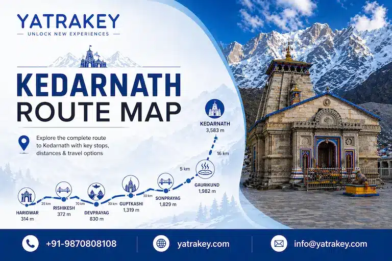
Planning your Kedarnath Yatra and wondering exactly which route to take? The Kedarnath route map covers more than just the famous 16 km trek from Gaurikund. It begins hundreds of kilometres away at the city you are starting from, passes through a chain of spiritually significant towns, and then breaks down into a mountain trail with checkpoints, rest points, and altitude markers that every pilgrim needs to know before arriving.
This complete guide covers the full Kedarnath Yatra route map for 2026, from the road journey to the trekking path, helicopter options, alternative trails, and the key locations that define the journey to one of India’s most sacred Jyotirlinga temples.
What Is the Kedarnath Yatra Route?
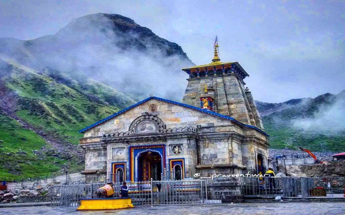
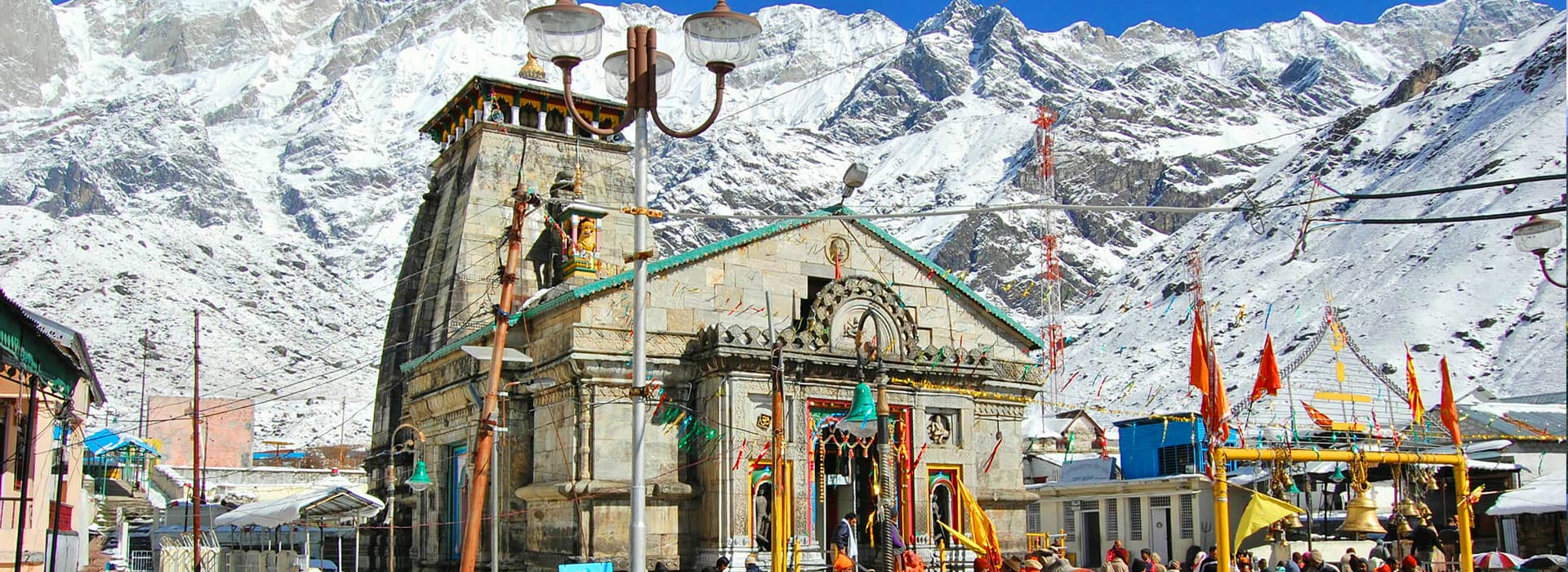
Kedarnath Temple sits at 3,583 metres above sea level in the Rudraprayag district of Uttarakhand, inside the Kedarnath Wildlife Sanctuary. The temple is dedicated to Lord Shiva and forms a key part of the Char Dham Yatra.
The complete Kedarnath yatra route is a combination of road travel and mountain trekking. No vehicle can take you all the way to the temple, the journey always ends with a trek or a helicopter flight. Understanding the full route before you travel saves time, prevents confusion at checkpoints, and helps you plan each overnight stop sensibly.
The standard route in brief:
Delhi / Haridwar / Rishikesh → Devprayag → Rudraprayag → Guptkashi → Sonprayag → Gaurikund → Kedarnath Temple (trek)
Kedarnath Route Map — Road Journey Stage by Stage
Stage 1: Delhi to Haridwar (Approx. 210 to 230 km)
Most pilgrims begin the Kedarnath road route from Delhi, traveling north via NH 334. Haridwar is the first major halt and the traditional gateway to the Chardham Yatra. The drive covers roughly 210 to 230 km depending on your departure point within the Delhi NCR region and takes around 5 to 6 hours by road.
Haridwar is also accessible by train from most major Indian cities, making it the natural assembly point for pilgrims traveling from distant states. From here, the pilgrimage road begins in earnest.
Stage 2: Haridwar to Rishikesh (24 km)
Rishikesh is just 24 km from Haridwar and serves as a second major staging point. Many pilgrims choose to spend a night here before the mountain drive begins. The town sits at the foothills of the Himalayas and is the last major flat-road stop on the Kedarnath yatra path.
Stage 3: Rishikesh to Devprayag (74 km)
After Rishikesh, the road begins climbing along the Ganga. Devprayag is where the Alaknanda and Bhagirathi rivers merge to officially form the Ganga. It is a culturally important stop and worth a brief visit, though most pilgrims pass through without an overnight halt.
Stage 4: Devprayag to Rudraprayag (via Srinagar, approx. 67 km)
The route passes through Srinagar (the Uttarakhand town, not the one in Kashmir) before reaching Rudraprayag, the district headquarters and another river confluence point where the Mandakini meets the Alaknanda. Rudraprayag is a popular overnight stop for pilgrims driving from Rishikesh and serves as a key town on the Kedarnath dham route map.
Stage 5: Rudraprayag to Guptkashi (Approx. 74 km via Agastmuni and Kund)
This stretch carries you deeper into the mountains through towns including Tilwara, Agastmuni, Chandrapuri, Kund, and Phata before reaching Guptkashi. Guptkashi is one of the most important overnight stops on the entire Kedarnath route from Haridwar. It has the last reliable ATMs before the trek, a good selection of accommodation, and is the base town for helicopter bookings at the nearby Phata and Sitapur helipads.
Important: Carry sufficient cash before leaving Guptkashi. ATM availability beyond this point is extremely limited.
Stage 6: Guptkashi to Sonprayag (Approx. 25 km)
Sonprayag is where your QR-coded yatra pass gets scanned for the first time. This checkpoint controls pilgrim movement toward Gaurikund. Private vehicles are not allowed beyond Sonprayag. From here, only shared government taxis and local jeeps cover the final 5 km stretch to Gaurikund.
Stage 7: Sonprayag to Gaurikund (5 km)
Gaurikund is the last motorable point on the Kedarnath Dham road map and the official starting point for the 16 km trek to the temple. It sits at an altitude of roughly 1,982 metres (6,503 feet). Gaurikund has a natural hot water spring considered sacred, a few guesthouses, dhabas, and pony and palki booking counters.
Also Read: Can Kedarnath Be Visited Without Trekking?
Complete Road Distance Chart — Kedarnath Route Map
| Route Segment | Distance (Approx.) |
|---|---|
| Delhi to Haridwar | 210 to 230 km |
| Haridwar to Rishikesh | 24 km |
| Rishikesh to Devprayag | 74 km |
| Devprayag to Rudraprayag (via Srinagar) | 67 km |
| Rudraprayag to Guptkashi | 74 km |
| Guptkashi to Sonprayag | 25 km |
| Sonprayag to Gaurikund | 5 km |
| Total: Delhi to Gaurikund | Approx. 450 km |
| Gaurikund to Kedarnath Temple (trek) | 16 km |
| Total journey: Delhi to Kedarnath | Approx. 466 km + 16 km trek |
Kedarnath Trek Route Map — Gaurikund to Kedarnath Temple
The Gaurikund to Kedarnath route is 16 km one way and runs entirely uphill. The total altitude gain from Gaurikund (1,982 m) to Kedarnath Temple (3,583 m) is approximately 1,600 metres. This is the section of the Kedarnath trek route map that demands the most physical preparation.
The route passes through five main waypoints, each serving as a rest, food, and emergency stop.
Checkpoint 1: Gaurikund (Altitude: 1,982 m / 6,503 ft)
Starting point of the trek. Gaurikund is believed to be the place where Goddess Parvati meditated to seek Lord Shiva’s attention. A natural hot water spring is present here. Pony, palki, and porter booking counters operate from Gaurikund. Start your trek no later than 5:00 AM during peak season.
Distance from here to Kedarnath Temple: 16 km
Checkpoint 2: Jungle Chatti / Bhairav Chatti (Altitude: Approx. 2,650 m)
Located 4 km from Gaurikund, Jungle Chatti is the first official rest point on the Kedarnath trekking route map. Food stalls, tea shops, and resting sheds are available here. This is also where the forest trail begins and pilgrims start feeling the incline become steeper.
Distance from Gaurikund: 4 km
Checkpoint 3: Bheembali (Altitude: Approx. 3,100 m)
Bheembali sits 7 km from Gaurikund and is one of the most important stops on the entire route. A medical and first aid facility is stationed here. This is where altitude begins to affect pilgrims who are not acclimatised, and it is a mandatory rest point for anyone feeling breathless. The incline beyond Bheembali becomes notably sharper.
Distance from Gaurikund: 7 km
Checkpoint 4: Lincholi / Linchauli (Altitude: Approx. 3,250 m)
Lincholi is 11 km from Gaurikund and is known informally as the “oxygen zone” — the point where many pilgrims begin to feel the physical effects of high altitude most strongly. Another medical aid post is located here. GMVN (Garhwal Mandal Vikas Nigam) accommodation is available for pilgrims who need to break the trek across two days.
Distance from Gaurikund: 11 km
Checkpoint 5: Kedarnath Base Camp (Altitude: Approx. 3,500 m)
The base camp is 15 km from Gaurikund and gives pilgrims the first clear view of the Kedarnath peak (6,940 m) towering behind the temple. Tent accommodation, food stalls, and rest areas are available here. A 10-bed hospital with ECG equipment and modern facilities operates at the Kedarnath base during the yatra season.
Distance from Gaurikund: 15 km
Final Destination: Kedarnath Temple (Altitude: 3,583 m / 11,755 ft)
The temple sits another 1 km from the base camp, on the banks of the Mandakini River near the Chorabari Glacier. Darshan timings run from 6:00 AM to 3:00 PM and again from 5:00 PM to 8:00 PM. The last entry timing for upward trekkers is 5:00 PM.
Total Trek Distance (One Way): 16 km Total Trek Distance (Return): 32 km Trekking Time (Upward): 6 to 10 hours depending on fitness Trekking Time (Downward): 4 to 6 hours
Trek Checkpoint Distance Table — Kedarnath Route
| Segment | Distance |
|---|---|
| Gaurikund to Jungle Chatti | 4 km |
| Jungle Chatti to Bheembali | 3 km |
| Bheembali to Lincholi | 4 km |
| Lincholi to Kedarnath Base Camp | 4 km |
| Kedarnath Base Camp to Temple | 1 km |
| Total One Way | 16 km |
Kedarnath Helicopter Route Map — Helipad Locations
For pilgrims who cannot trek or are short on time, helicopter services operate from multiple points close to the Kedarnath yatra route. The flight takes roughly 7 to 10 minutes depending on the helipad.
Operating Helipads for Kedarnath 2026:
- Phata Helipad — approximately 15 km from Gaurikund, most popular helipad on the route
- Guptkashi Helipad — located in the main town, convenient for those staying overnight in Guptkashi
- Sirsi / Sersi Helipad — operates during peak season, close to Sitapur
- Agastyamuni Helipad — farther down the valley, used during high-demand periods
All helicopter bookings for Kedarnath require your Yatra Registration Number from the official Uttarakhand portal. Book through the IRCTC HeliYatra portal. Due to high demand, helicopter seats sell out weeks in advance during May and June.
Also Read: Kedarnath Helicopter Fare Hike 2025
Alternative Kedarnath Trekking Routes
Beyond the standard Gaurikund path, two less-traveled alternatives exist for experienced trekkers who want to avoid the crowds on the main trail.
Alternative Route 1: Sonprayag to Kedarnath (Approx. 22 km)
This route begins from Sonprayag itself and bypasses both Gaurikund and Rambara. It is a longer trail at approximately 22 km, runs through quieter forested sections, and connects eventually to the Vasuki Tal trail before reaching the temple. It suits experienced walkers who want a more contemplative, less crowded approach. Check local advisories before attempting this in 2026.
Alternative Route 2: Chaumasi to Kedarnath (via Kham Bugyal, Approx. 34 km, Two Days)
This offbeat route starts from Chaumasi village near Guptkashi and takes trekkers through dense forests, Kham Bugyal meadows, the Mandani Valley, and across glacial terrain before arriving at Kedarnath. It is a two-day trail and strictly for experienced, well-equipped trekkers. The route passes through some of the most isolated Himalayan landscape in the entire Kedar Valley and requires a local guide.
Beyond Kedarnath — Side Routes Worth Knowing
Once you reach the temple, two extensions are accessible for those who want to go further into the Kedar range.
Gandhi Sarovar (Chorabari Tal) — 2 km from Kedarnath Temple
A glacial lake formed by the Chorabari Glacier, Gandhi Sarovar is a short 2 km walk from the temple. The lake sits in a quiet hollow surrounded by rocky peaks and holds spiritual significance for devotees. It is an easy extension for most pilgrims already at Kedarnath.
Vasuki Tal — 8 km from Kedarnath Temple
Vasuki Tal is a high-altitude glacial lake at approximately 4,800 metres above sea level, about 8 km beyond the Kedarnath Temple. The trail passes through rugged terrain with sweeping views of the Chaukhamba peaks. According to Hindu tradition, Lord Vishnu bathed in this lake on the occasion of Raksha Bandhan. The route from Gaurikund to Vasuki Tal, if combined, covers approximately 24 km. This extension suits experienced trekkers with an extra day and strong fitness. The trek to Vasuki Tal is best attempted between June and early October.
How to Reach Kedarnath — Transport Options on the Route
By Air
The nearest airport to Kedarnath is Jolly Grant Airport in Dehradun, approximately 250 km from Gaurikund. From the airport, hire a private taxi or take a connecting bus to reach Sonprayag or Gaurikund. The drive from Dehradun to Gaurikund takes roughly 8 to 9 hours depending on road conditions.
By Train
The nearest railway stations are Haridwar (approx. 240 km from Gaurikund) and Rishikesh (approx. 215 km). Both are well connected to Delhi, Mumbai, Kolkata, and other major cities. From either station, taxis, shared jeeps, and Uttarakhand Transport Corporation buses run to Gaurikund.
By Road
The most common way to travel the Kedarnath road route is by private taxi from Haridwar or Rishikesh. Shared taxis and UPSRTC and UTC buses also operate on this route during the yatra season. Private vehicles can travel up to Sonprayag, after which only authorised local transport is permitted to Gaurikund.
By Helicopter
Helicopter services from Phata, Guptkashi, and Sirsi connect directly to Kedarnath. The flight lasts 7 to 10 minutes. Book in advance through the IRCTC HeliYatra portal after completing your yatra registration.
Kedarnath Route — Important Tips for 2026 Pilgrims
- Start the trek early. Leave Gaurikund by 5:00 AM at the latest during peak months. Starting early means better weather, fewer crowds, and more time to rest before darshan.
- Do not skip Sonprayag checkpoint. Your QR-coded yatra pass is scanned here. Pilgrims without a valid pass are not allowed to proceed.
- Carry cash from Guptkashi. ATMs are unavailable beyond Guptkashi. You will need cash for food, porters, and emergency pony hire along the trek.
- Do not rush the climb. The altitude gain between Lincholi and the base camp is significant. Walk slowly, breathe steadily, and stop at Bheembali and Lincholi to rest properly.
- Carry rain protection. Mountain weather changes fast. A light waterproof jacket or poncho is mandatory between May and October.
- Acclimatise where possible. If you are arriving from a low-altitude city, spending a night at Guptkashi or Rudraprayag before the trek gives your body time to adjust.
- Keep your trek pass and ID handy. Multiple checkpoints along the 16 km trail scan QR codes and check IDs. Keep both accessible.
- Book accommodation in advance. GMVN huts, guesthouses at Lincholi, and tents near the temple base camp fill up weeks in advance during May and June. Nighttime temperatures near the temple frequently drop below 0 degrees Celsius.
Kedarnath Route Map — Weather by Month
| Month | Conditions on Route |
|---|---|
| April (from 22nd) | Cold mornings, possible snow near temple, fewer pilgrims |
| May to June | Best weather, very high crowd levels, slots and helicopters book up fast |
| July to August | Monsoon season, landslide risk, road disruptions, not recommended |
| September to October | Clear skies, cool temperatures, moderate footfall, excellent conditions |
| November (till 11th) | Temple closes, cold sets in, limited facilities |
Plan Your Kedarnath Yatra with YatraKey
Knowing the Kedarnath route map is the first step. Turning that knowledge into a smooth, safe pilgrimage requires the right travel partner. YatraKey is an IATA-approved travel agency based in Haridwar with direct, first-hand experience on every segment of the Kedarnath Yatra route.
The team at YatraKey has guided pilgrims across the full Chardham circuit through multiple seasons, understands the ground conditions at each stop, and manages every logistical detail so your focus remains entirely on the pilgrimage.
YatraKey packages for the Kedarnath Yatra:
- Complete Chardham Yatra packages with accommodation at all key route stops
- Char Dham by helicopter for pilgrims using the aerial route to Kedarnath
- Do Dham Yatra packages covering Kedarnath and Badrinath
- Char Dham Yatra by road for a complete overland journey
- Private car rental for groups wanting dedicated transport from Haridwar to Sonprayag
- Hotel booking assistance at Guptkashi, Rudraprayag, Rishikesh, and Haridwar
Contact YatraKey: Phone: +91-9870808108 | WhatsApp: Chat Now | Email: info@yatrakey.com | Office: Near Gate No. 2, Shantikunj Bhoopatwala, Haridwar, Uttarakhand 249410
Frequently Asked Questions — Kedarnath Route Map 2026
1. What is the Kedarnath route map from Delhi?
The standard Kedarnath route from Delhi covers approximately 450 km by road to Gaurikund, followed by a 16 km trek to the temple. The route runs: Delhi → Haridwar → Rishikesh → Devprayag → Rudraprayag → Guptkashi → Sonprayag → Gaurikund → Kedarnath Temple. The road journey takes 10 to 12 hours, typically split across two days.
2. What is the distance from Gaurikund to Kedarnath Temple?
The Gaurikund to Kedarnath distance is 16 km one way, entirely uphill. The round trip on foot covers 32 km. The trek passes through Jungle Chatti, Bheembali, Lincholi, and Kedarnath Base Camp. Most pilgrims take 6 to 10 hours to complete the ascent depending on their fitness level and pace.
3. How many checkpoints are there on the Kedarnath trek route?
The Kedarnath trekking route has approximately 10 checkpoints in total. The five major waypoints with rest facilities and medical support are Gaurikund, Jungle Chatti, Bheembali, Lincholi, and Kedarnath Base Camp. Medical aid posts operate at Bheembali, Lincholi, and the base camp throughout the yatra season.
4. What is the helicopter route for Kedarnath?
The Kedarnath helicopter route operates from helipads at Phata, Guptkashi, and Sirsi to the Kedarnath helipad near the temple. The flight covers approximately 15 km and takes 7 to 10 minutes. Helicopter bookings are made through the IRCTC HeliYatra portal and require a completed yatra registration number.
5. Are private vehicles allowed on the Kedarnath route?
Private vehicles are permitted up to Sonprayag on the Kedarnath road route map. Beyond Sonprayag, only authorised shared government taxis and local jeeps are allowed to travel the final 5 km to Gaurikund. Parking facilities are available at Sonprayag.
6. What is the best route to reach Kedarnath from Haridwar?
The Kedarnath route from Haridwar follows NH 7 through Rishikesh, Devprayag, Rudraprayag, Guptkashi, and Sonprayag before reaching Gaurikund. The road distance from Haridwar to Gaurikund is approximately 240 km and takes 8 to 9 hours by taxi or bus.
7. Is there an alternative trek route to Kedarnath other than Gaurikund?
Yes, two alternative routes exist. The first runs from Sonprayag directly to Kedarnath, covering approximately 22 km. The second is the Chaumasi to Kedarnath route via Kham Bugyal, covering around 34 km across two days. Both suit experienced trekkers only and require checking local advisories before undertaking in 2026.
8. What altitude is Kedarnath Temple on the route map?
Kedarnath Temple sits at 3,583 metres (11,755 feet) above sea level. The Kedarnath altitude at Gaurikund, the trek starting point, is 1,982 metres. The total elevation gain across the 16 km trek is approximately 1,600 metres, making acclimatisation and a steady pace essential.
9. What are the key towns to stop at on the Kedarnath yatra route?
The key overnight stops on the Kedarnath yatra path are Haridwar or Rishikesh (Day 1), Rudraprayag or Guptkashi (Day 2), and Gaurikund (Day 3, before the trek). Pilgrims arriving by air via Dehradun can join the standard route at Rishikesh or Rudraprayag without backtracking.
10. Can I visit Vasuki Tal from the Kedarnath route?
Yes. Vasuki Tal is accessible from the Kedarnath Temple itself, approximately 8 km further into the Kedar range at an altitude of 4,800 metres. It is a moderately difficult extension trek best attempted between June and October by pilgrims who are already fit from the Gaurikund to Kedarnath ascent. The total trail from Gaurikund to Vasuki Tal covers approximately 24 km one way.
For complete Kedarnath Yatra planning including registration guidance, accommodation booking, and curated travel packages, visit YatraKey Tour Packages or contact the team at +91-9870808108. YatraKey is not affiliated with the Uttarakhand Government or IRCTC.